ASHLAND, Ore. – March may well go out like a lamb, but the warm lion chasing it through Pacific Northwest vineyards has been slowed down by a soggy coat from El Niño.
Gregory Jones, the U.S. wine industry’s leading expert on climate research, issued his winter weather update on Friday. For parts of the West, it hasn’t been a typical El Niño.
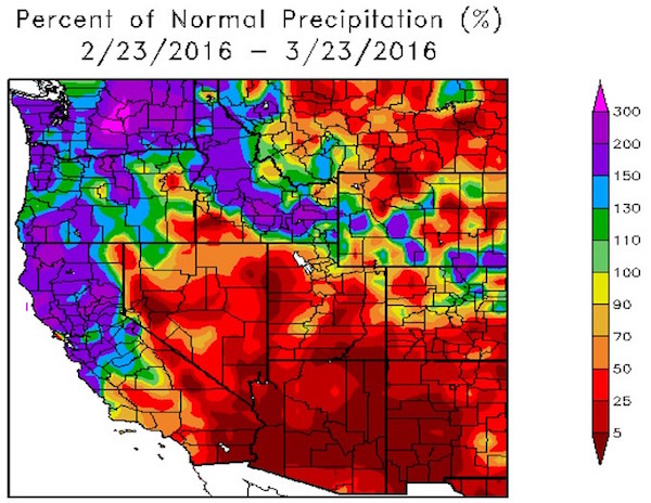
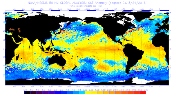
“The last 30 days has seen 150-300% or more of normal precipitation to areas from just south of the Bay Area, throughout Northern California, into much of Oregon, Washington and Idaho,” the Southern Oregon University professor wrote. “Southern California and the Southwest continued dry over this period, nearly the opposite of what would be expected in a normal El Niño year.”
While February can be described as warm and dry, March is looking to grade out as warm and wet.
“Over the last 30 days, temperatures have been above normal throughout the West, with departures of 1-2°F in most locations but 5-7°F in the Southwest and up to 10°F in the northern Rockies,” Jones wrote. “The rest of the United States has seen similar conditions over the last 30 days with temperatures above normal, with especially warm conditions across the northern tier of states, into New England and the mid-Atlantic.”
Water year blends wet, warm conditions
The water year for 2016, which begins in October, might be a worry for irrigators in some portions of the Pacific Northwest because of the warmer-than-average winter.
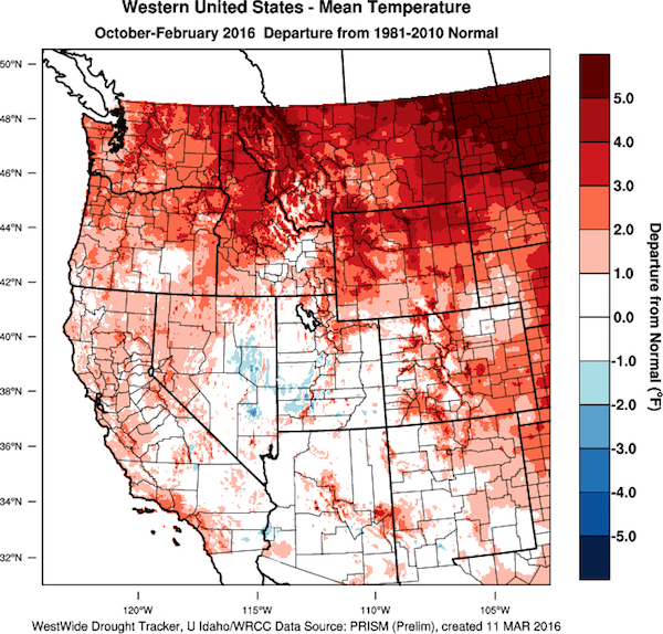
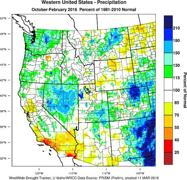
“Average temperatures for the period have run 1.0-4.0°F or more above the 1981-2010 climate normals for much of California, Oregon and Washington,” Jones reported. “This pattern continues across the entire U.S., with temperatures running 1.0-3.0°F above normal. Precipitation amounts since October have been near normal to above normal from Northern California, across Nevada and into the PNW, while the Southwest has remained mostly drier than expected.
“The current U.S. Drought Monitor reflects the water year precipitation pattern with continued dry conditions in central and southern California into the Southwest and Great Basin, and a return to normal conditions in portions of Western Oregon, much of Washington and much of the rest of the U.S,” he added.
Models indicate transition to La Niña in fall
The Climate Prediction Center and other agencies report there are signs the current strong El Niño will continue to weaken with a transition to El Niño–Southern Oscillation neutral during June or July.
“Forecasters from many governments in the Pacific are in agreement with the general model consensus, though the exact timing of the transition is difficult to predict,” Jones wrote. “However, El Niño effects throughout the region are expected to continue as there is a lag time from when the ocean temperatures shift to when the atmosphere responds.
“All observation agencies are now pointing to 50 percent or greater likelihood that we will transition into La Niña conditions next fall, which would likely spell a colder and snowier winter.”
North Pacific key to 4 warm El Niño vintages
The wine industry on the West Coast, particularly the Pacific Northwest, has benefited from four consecutive warm vintages, starting with the near-perfect 2012 growing season. Consumers, critics and judges at wine competitions largely have embraced the wines, particularly the supple and ripe reds.
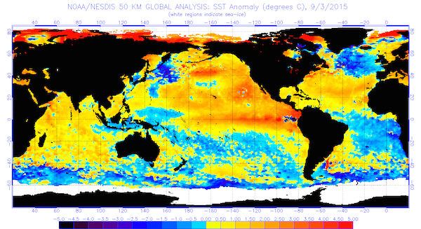
Jones points to the North Pacific sea surface temperatures as a major factor.
“During 2012-2015, the North Pacific was much warmer than normal and contributed to our warm years, especially higher minimum temperatures,” Jones wrote. “However, the North Pacific SSTs have unexpectedly cooled, even along much of the western North American coast.
“The result was likely the shift in the jet stream and a more vigorous late winter precipitation pattern in the West,” Jones continued. “This shift to cooler waters in the North Pacific causes me more concern than what is happening in the tropics, and as such I will monitor how it evolves over the next few months.”
April ridge building brings frost worries
Weather services predict the latter part of this final week of March could see temperatures in reach 70 degrees in the Columbia Valley.
“The models are pointing to a ridge building in over the Western U.S., a trough across the center of the U.S. and a ridge over the eastern U.S,” Jones wrote. “If these conditions build in as expected, we will likely see a warm up over much of the western valleys in California, Oregon and Washington. However, a building ridge will bring clear nights which will likely bring many locations to freezing or below.”
Indeed, April should bring more warm and dry conditions in the Pacific Northwest.
“The only concern here is the shifting of the North Pacific to cooler waters, which could keep minimum temperatures lower into the frost season,” Jones warned.
And the 90-day forecast mirrors the first 30 days, which would mean growers might worry about frost nipping at buds beyond Mother’s Day – the traditional end of such fears.
“The precipitation forecast for the West does not change much, with normal to slightly above normal rainfall expected from southern Oregon south throughout California, while the rest of the PNW is forecast to have a greater chance of seeing dry conditions over the next 90 days,” Jones concluded. “Again, the main concern here is the shifting of the North Pacific to cooler waters, which could keep minimum temperatures lower throughout the frost season.”
Leave a Reply