Vines are gradually coming out of their winter slumber, but the 2020 vintage already will be one that no wine lover in the Pacific Northwest will forget.
World-renowned climate researcher Greg Jones, who also serves as director of the Evenstad Center for Wine Education at Linfield College in McMinnville, Ore., issued his Weather and Climate Summary and Forecast for April on Friday. It looks back on why most of March made it a bit easier for many in the Pacific Northwest to self-isolate indoors during the COVID-19 outbreak.
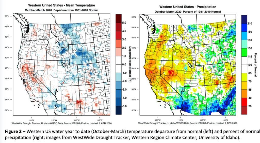
“March was relatively cool for much of the western US, slowing what appeared to be an early spring,” Jones wrote. “Temperatures were slightly above normal to 2.5°F below normal over most of the west.”
The official start to the recording of growing degree days, aka heat units, began Wednesday, April 1. Bud break in vineyards was reported in the Walla Walla Valley and Columbia Gorge on March 27, indicating the 2020 vintage closed out the month several days ahead of last year’s pace. However, the first weekend of April should slow down growth.
“The April through June seasonal forecast for the west coast is pointing to a cool and wet April, and then a warm and dry May and June,” Jones wrote. “The overall outlook is for the western US to likely end up slightly warmer than normal but staying drier than average for much of the PNW, northern California and the central Great Basin.”
Those around the Puget Sound lived through one of the wettest months of January in Seattle history, but all the precipitation to start 2020 was cheered by skiers, water managers and winegrowers as wet conditions (110-200% of normal for that month) were reported throughout Washington, Oregon and Idaho.
“The pattern of January precipitation lowered drought concerns in the PNW, while bringing back drought concerns in California,” Jones noted in February.
Snowpack for much of NW around 100% of normal
This past week, irrigators in some portions of the region found some comfort in the latest snowpack reports, yet drought fears remain for Oregon and portions of eastern Washington, according to Jones.
Indeed, the outlook for 2020 would be grim if not for that first month. The U.S. Natural Resources Conservation Service pointed out that a snowy January helped boost the snowpack in Washington, which languished at less than 50 percent of normal statewide on Christmas Day.
By April 1, the Lower Yakima River Basin got news that is 112 percent of normal. The Walla Walla Basin stood at 120%, and the Lower Columbia Basin charted at 111%.
For Oregon, the Willamette Basin was right at 100%, but in Southern Oregon, the Rogue and Umpqua Basin Index was 80%, while the water year-to-date percentage came in at just 69%.
Overall, the index for Idaho’s Snake River Basin was 89% on April 1.
“The short-term forecast is pointing to a cool/wet period through mid-month, with scattered frost potential depending on the timing of clearing skies between systems,” Jones wrote. “The longer-term outlook for the US through June continues to show the forecasted dry conditions for much of California, Oregon, and Washington with drought development and/or persistence through spring and into early summer.”
Leave a Reply