
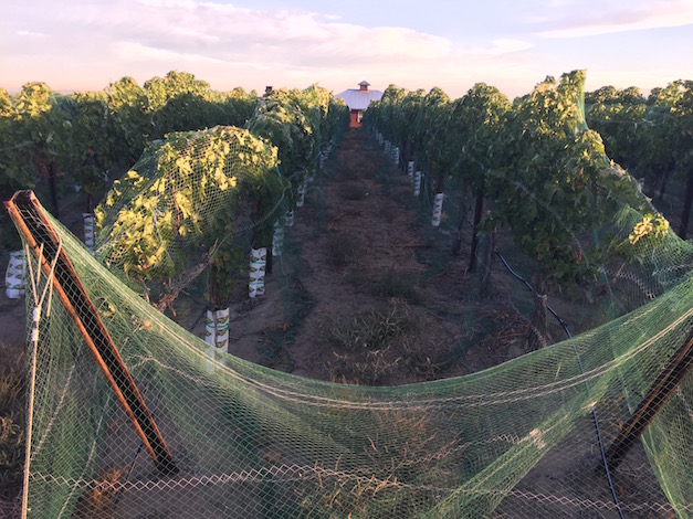
Many in the Pacific Northwest will remember the 2015 growing season for irrigation issues, smoke from wildfires and a string of 100-degree days starting in June, but it might go down as a vintage that leaves most of the region’s growers, vintners and consumers with smiles.
Harvest started early for nearly every grape-growing region in Washington, Oregon, Idaho and British Columbia. Picking already has ended for some, and there are no indications of a significant frost looming for the next two weeks.
“Cool nighttime temperatures are likely to continue, but there’s nothing approaching frost conditions in the 8-14 day forecast,” Greg Jones, climate expert at the Southern Oregon University, wrote Sunday in his latest report to the Pacific Northwest wine industry.
Washington wine, Walla Walla Valley on record pace
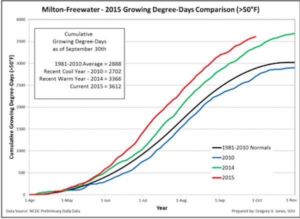
Meanwhile, the Walla Walla Valley is on track to easily surpass its record for growing degree days, set in 2014.
Jones, an environmental science professor at SOU and one of the planet’s top experts on researching the effects of climate change on viticulture, shared data from his weather station in the Walla Walla Valley town of Milton-Freewater, Ore. It registered 3,612 growing degree days this year as of Oct. 1. A year ago, there were a record 3,366 GDDs.
“Growing degree-days continue at slightly above to record numbers throughout the West,” he wrote. “Even with the September cool down, Washington has seen the largest increases in degree-day accumulations with totals as of Oct. 1 at 30-35 percent over the 1981-2010 averages, while in California wine regions are running 15-25 percent above normal.”
Data on Washington State University’s AgWeatherNet provides confirmation. Its Benton City site, which would serve as an indicator for Red Mountain, recorded 3,676 growing degree days through Oct. 4. Last year, during the Washington wine industry’s record hot vintage, there were just 3,370 GDD by comparison.
On the Wahluke Slope, which some view as the state’s warmest growing region for wine grapes, there were 3,876 GDD tallied through Oct. 4. A year ago, the total stood at 3,679.
Heat units in So. Oregon, Willamette Valley similar to 2014
“For Oregon, April through September accumulations are running close to the record numbers seen in 2014, and 20-25 percent above the 1981-2010 climate normals,” Jones wrote.
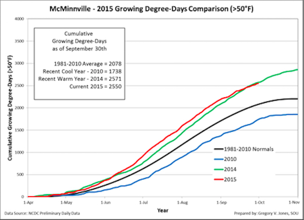
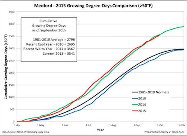
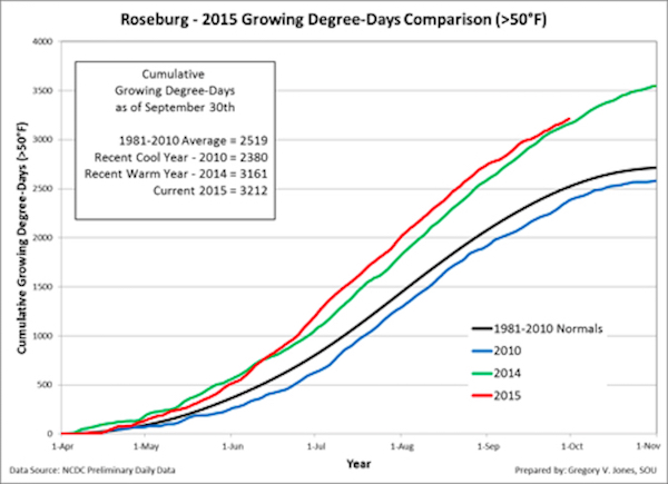
Indeed, the Willamette Valley weather station for Jones in McMinnville notched 2,550 GDDs. A year ago, the data collected 2,571 GDDs. Medford also was slightly behind last year’s pace, while Roseburg with 3,212 GDDs would seem on edge past last year’s record (3,161).
“Temperatures are forecast to trend warmer than normal over the entire western U.S,” Jones wrote. “Precipitation forecast two weeks out points to a continued drier than normal California and interior western U.S. states. The Pacific Northwest has a higher likelihood of near normal to slightly higher than normal precipitation.”
Growing season for pending El Niño could match 2005 vintage
Indications for this winter continue to point toward an El Niño, according to Jones.
“Current long lead forecasts are giving it a 90 percent chance of lasting through winter and 80 percent chance of lasting into spring 2016,” Jones wrote. “While it appears that the El Niño will likely bring welcomed moisture this fall/winter to Southern California, the desert Southwest, and the Great Basin, how far it reaches northward and how much it brings are the unknowns.”
Beyond that, forecast models for a summer that’s part of such an El Niño, would match some respectable vintages in the Pacific Northwest.
“Similar conditions in the last 30 years occurred during the 1992, 1998, 2003, 2004, and 2005 growing seasons,” Jones wrote.
Leave a Reply