As predicted, the 2016 vintage would seem to indicate the start of a gradual shift from El Niño toward La Niña for much of the Pacific Northwest wine industry.
Southern Oregon University researcher Greg Jones issued his “Summer to Harvest” report during Labor Day weekend, noting that, “With school and football season starting, a hint of fall is right on time, and the transition has started.”
Last year’s record-setting heat for the 2015 vintage made for an early start in the Pacific Northwest. The 2016 growing season hasn’t match that, yet the decades-long tradition of winemakers holding off bringing fruit in until after Labor Day is in the rear-view mirror for many.
“The growing season continues to run roughly 10-20 days ahead of the long-term average across the majority of the western U.S., but is now almost guaranteed to end up lower than 2015,” wrote Jones, an international leader for the wine industry in terms of climate research.
And the unseasonably cool Labor Day weekend also added to the slowdown in the ripening curve.
Nic Loyd of Washington State University’s AgWeatherNet provided some context.
“For the first time in a long time, I can make the following statement unequivocally: Cooler than normal conditions are likely for at least the next five days,” he wrote. “The month of September marks the beginning of meteorological autumn, and the climate system will agreeably reflect this seasonal shift right on schedule. As has been mentioned before, but deserves repeating, the expected temperatures are not at all unusual by historical standards, but may feel rather abnormal given the relatively hot climate of recent years.”
Growing degree days chart lower
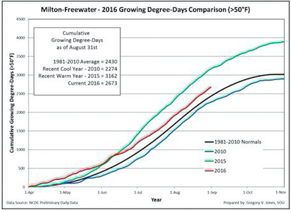
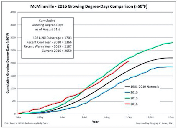
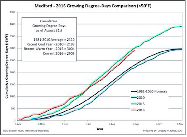
That hot and record-setting start to the 2016 growing season slowed down after June, reflected in the growing degree days comparison for the Walla Walla Valley.
Jones’ weather station in Milton-Freewater showed the GDD for 2016 dipped just below that of 2015 and continues along the same path. On Aug. 31, the Walla Walla Valley stood at 2,673 GDD, which trailed the record 2015 vintage at 3,162.
In the heart of the Willamette Valley, Jones’ station checked in with 2,059 GDD. Last year at the same date, the McMinnville device stood at 2,187.
Research in Medford, a few miles north of the Southern Oregon University campus, shows the Rogue Valley tracking just behind the 2015 vintage and well beyond the 1981-2010 normals, and award-winning DANCIN Vineyards harvested Pinot Noir on Aug. 24.
Washington State University’s AgWeatherNet charts growing degree days throughout the Evergreen State as well as parts of Oregon. Through Aug. 31, there were 3,028 growing degrees days recorded at the Wahluke Slope station. A year ago, it charted 3,349 GDD.
At the Benton City station near Red Mountain, there were 2,938 GDD recorded. A year ago, it ended at 3,139 GDD. On Snipes Mountain in the Yakima Valley, there were 2,788 GDD registered. A year ago, the accumulation stood at 3,043 GDD.
The Pullman school’s station in Woodinville stood at 1,652 GDD, compared with 1,831 GDD in 2015. In the Columbia Gorge, Oregon’s Hood River County station already notched 2,152 GDD. A year ago, it stood at 2,315.
Average temperatures have run 1-4°F or more above the 1981-2010 climate normals for much of California, Oregon, Idaho and Washington. Precipitation has been 90 to 150 percent of normal from Northern California into southern Oregon and the Columbia Valley. Eastern Oregon, the Lewis Clark Valley and the Snake River Valley of Idaho continued to see dry conditions.
“January through August accumulations are running near normal up to 500 units higher than the 1981-2010 normals throughout much of the western wine regions,” Jones wrote. “GDD accumulation in August was higher than average in most regions, with the exception of eastern Washington/Oregon and portions of the North and Central Coast of California.”
Labor Day conditions continue this week
Research from the Climate Prediction Center, according to Jones, indicates the next week will bring greater chances for cooler-than-normal and higher-than-average rainfall across Washington, but warmer than normal for southern Oregon.
Conditions for the Pacific Northwest during the final two weeks of September are expected to be warmer and drier than the 30-year normal. In fact, the 90-day forecast calls for more of the same.
“The broken record continues from the majority of the forecast community with the September-October-November (SON) forecast pointing to the majority of the continental United States having elevated chances of well above average fall temperatures,” Jones wrote. “There are no substantial changes to the pattern in the western U.S. with everywhere in California, Oregon, Washington and Idaho expected to see higher than normal temperatures.”
However, Jones warned some climate experts are calling for an early and stormy winter for the West in the second half of October.
“The expansion of the warm pool in the North Pacific in August should support a warmer than average ending to the growing season, but there is some indication of early shifts in circulation coming off of Siberia that might bring earlier than anticipated fall troughing and low pressure systems across the North Pacific and into the PNW,” Jones wrote.
Arctic warming may temper La Niña
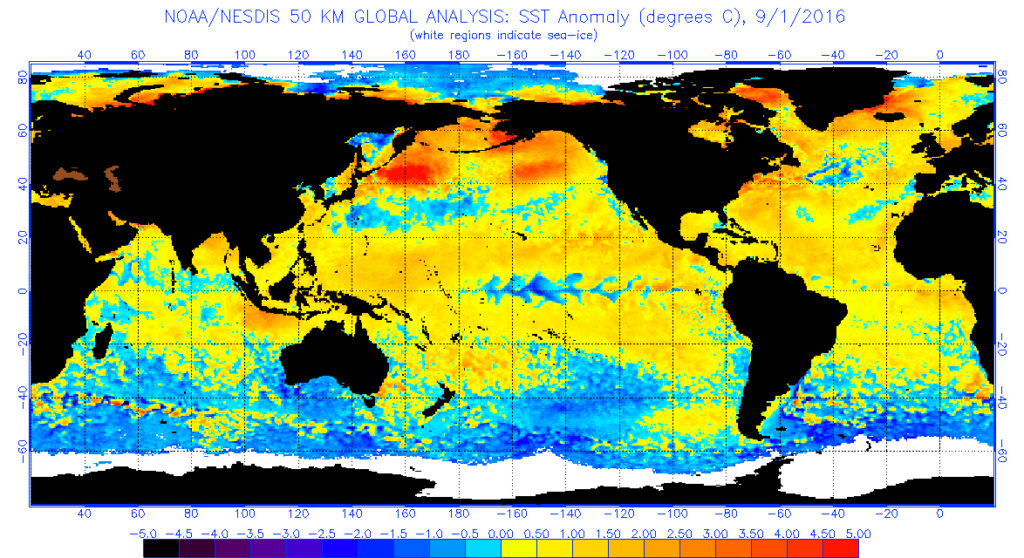
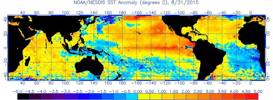
Jones, who earned his doctorate at the acclaimed University of Virginia, and his colleagues continue to monitor the sea surface temperatures in the western portion of the North Pacific and the El Niño Southern Oscillation (ENSO) for clues on what the winter of 2016-17 will bring.
“The shift to cooler surface waters in the tropical Pacific across the equator toward the central Pacific reflects the continued waning of El Niño and the developing La Niña conditions,” Jones wrote. “Prediction models are in agreement that La Niña development is extremely likely by fall. If the transition into La Niña conditions by fall materializes, the western U.S. would likely experience a colder and snowier winter.
“However, many forecasters are hedging their bets lower with moderate to minor La Niña development,” Jones added. “But all forecasters are saying that we should not expect this La Niña to follow ‘normal’ conditions from the western to eastern U.S. due to Arctic warmth.”

Leave a Reply