It was drier and a warmer-than-average month of August throughout Pacific Northwest vineyards, and that is forecast to continue through September, according to acclaimed climate researcher Greg Jones.
Jones continues to study the effects of climate change on vineyards throughout the world while serving as the CEO for Abacela, his family’s winery and vineyard in Roseburg, Ore. On Sunday, he issued his latest Weather and Climate Summary and Forecast for the Northwest wine industry.
“Harvest has started in California but lagging in Oregon, Washington and Idaho,” Jones wrote. “The 90-day forecast is holding to warmer and drier than normal for September, potentially wet and cool in October, and dry with a near-normal-to-warm November over most of the West.”
That forecast will generate some concern for Oregon’s wine industry, particularly those who focus on Pinot Noir in the Willamette Valley and expect to harvest the delicate and prized variety throughout October. Vineyard managers and winemakers would prefer to avoid rain while bringing in those grapes.
Despite the cool start to summer, portions of the Pacific Northwest have set records for high temperatures. In Washington state’s community of the Tri-Cities, which is in the Columbia Valley, Aug. 3 set a record as the 11th day in a row with a high temperature of at least 100 degrees. It broke the record of 10 in 1967, according to the weather service.
A week later in the Walla Walla Valley, a hailstorm sheared much of the 2022 vintage from Birch Creek Vineyard — a 30-acre estate planting for Dumas Station Wines in the Walla Walla Valley near Milton-Freewater, Ore.
“The PNW, Northern Rockies and most of California experienced August temperatures 2-7 degrees above average, while much of the desert southwest was closer to average due to increased cloud cover, higher humidity levels, and precipitation from the monsoon flow,” Jones wrote.
Much of Northwest 1-4 degrees cooler than average


Despite the heat of August and the rapid climb of growing degree days, grape harvest for most in the Pacific Northwest trails that of recent vintages. A key reason is that vines shut down when the temperature goes beyond 95 degrees. Treveri Cellars, a decorated sparkling wine producer in Washington’s Yakima Valley, harvested Chardonnay from the Grieb family’s estate vineyard on Aug. 31. Christian Grieb told the Washington Wine Report that was 19 days later than in 2021.
Data provided by Jones provides more detail.
“Year-to-date, the western U.S. is close to average to above average,” Jones wrote. “The warmest areas so far have been throughout most of California, while the coolest conditions year-to-date have been seen in the inland PNW with eastern Washington, eastern Oregon, the Snake River Valley, and most of Idaho, with 1-4 degrees below average for the year.”
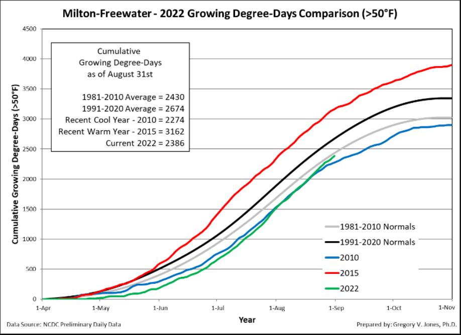
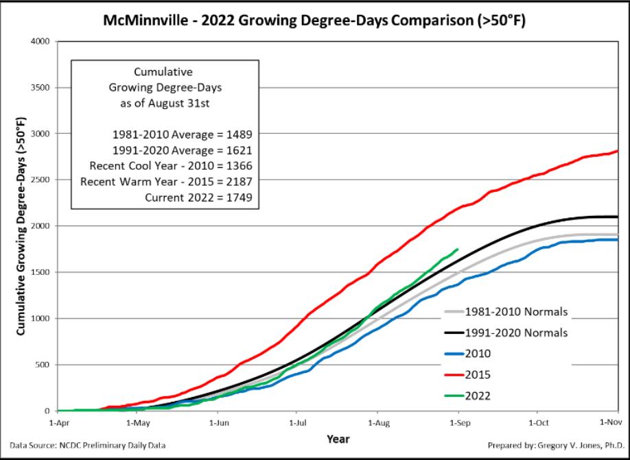
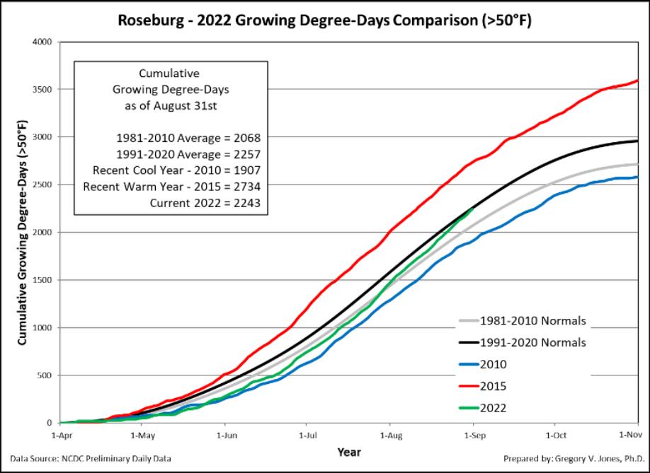
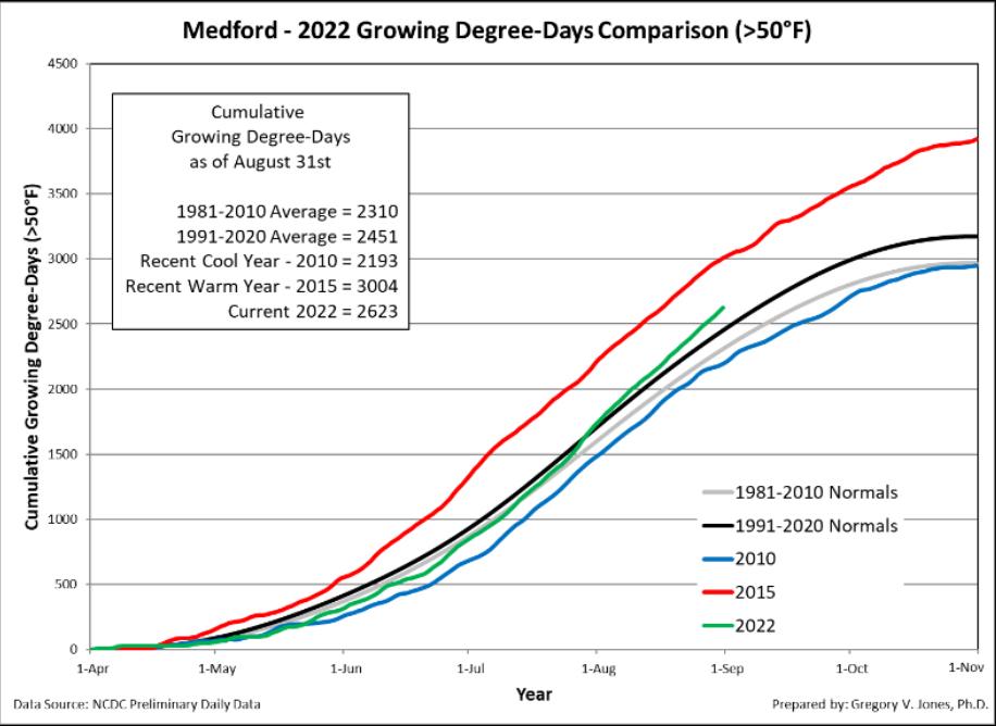
Jones shared data derived from his four baseline regions throughout Oregon, a network that includes Milton-Freewater in the Walla Walla Valley, McMinnville in the heart of the Willamette Valley, Roseburg in the Umpqua Valley and Medford in the Rogue Valley. His reports of heat accumulation (GDD) showed that McMinnville, Roseburg and Medford are in line or slightly above the 1991-2020 climate normals. Milton-Freewater is running cooler, about 15% off last year’s GDD but as much as 30% beyond the GDDs for the historically cool 2010 and 2011 vintages.
“Western Oregon is now running mostly near average to 100-200 GDD above average, while eastern portions of the inland PNW are near average to 50-150 GDD below average,” Jones wrote. “Wine regions in western Oregon are now running 6 days ahead to 2 days behind, while eastern Oregon and Washington, along with the Snake River Valley are 2-10 days behind the normal accumulation by the end of August.”
Washington State University’s AgWeatherNet logs growing degree days via its 177 stations across the state as well as in parts of Oregon and Idaho.
Through Aug. 31, there were 2,496 growing degree days recorded at the East Mattawa Station on the Wahluke Slope. A year ago, it charted 2,982 GDD. The six-year average is 2,742. During the 2017 vintage, it stood at 2,641 when September began.
At the Benton City station near Red Mountain, there were 2,639 GDD recorded. A year ago, it read 3,150 GDD. The six-year average is 2,894. During the 2017 vintage, it stood at 2,829 when September began.
On Snipes Mountain in the Yakima Valley, there were 2,537 GDD registered. The six-year average was not available. During the 2017 vintage, September began with 2,721.
At the Alderdale station in Klickitat County’s Horse Heaven Hills, it measured 2,336 GDD. The six-year average was 2,544. During the 2017 vintage, it stood at 2,614 when August began.
Along the Columbia Gorge, Husum notched 1,641 GDD. The six-year average was 1,895. During the 2017 vintage, it stood at 1,925 when September began. The Woodinville station for WSU wasn’t far behind Husum — 1,573 GDD. The recent average is 1,576, and in 2017 there were 1,523 heat units recorded.
In the Lewis-Clark Valley, an AVA that includes Idaho and Washington, Umiker Vineyard – the estate planting for Clearwater Canyon Cellars in Lewiston, Idaho — recorded 2,609 GDD through Aug. 31. At the same stage last year, there were 3,111 GDD.
On the Idaho side of the Snake River Valley, Dude DeWalt Vineyard in the Eagle Foothills reportedly received 2,002 GDDs, trailing the 2021 vintage’s 3,023 heat units.
Viticulture research technician Brad Estergaard compiles data for the British Columbia Grape Growers Association. This week, he provided updated growing degree days through August. The station for Osoyoos — the Okanagan Valley resort town that shares the namesake lake with Oroville, Wash. — recorded 1,625 GDD when converted to Fahrenheit. That figure trails the 1,764 GDD of the 2015 vintage and the 1,758 of a year ago.
On the Naramata Bench, there were 1,566 GDD recorded. Last year, they stood at 1,692. Tracking from that station began with the 2020 vintage.
The weather station positioned on the Golden Mile Bench leads the Okanagan Valley recording sites Estergaard charts with 1,681 GDD, behind the 1,790 from a year ago at sunrise on Sept. 1. The GDD to start September in 2015 was 1,820.
As for the upcoming winter, Jones noted that the Climate Prediction Center observations of the sea surface temperatures in the Pacific Ocean continue to forecast another La Nina for the start of 2023. That would mean the Northwest will experience cooler and wetter than normal conditions for a third consecutive year — which has happened just twice since 1950.

Have you every tried “Red” by FireHawk in Salem?